 The East is full of history, spanning the first American settlements to the Salem witch trials to the Revolutionary War to the Civil War. Having grown up in Massachusetts and majored in history education in college, Bob knows a lot about our country’s beginning. He introduced me to historical sites in his home state during my visits there in the early days of our relationship. I didn’t know a lot about the Civil War, though. I knew it was the bloodiest battle in American history and that it was fought between North and South about states’ rights, especially in regard to slavery, but not much more than that. We decided to explore some of the amazing landmarks that hearken back to Civil War days as we made our way up the East Coast, starting in Charleston, South Carolina. The state of Virginia played a pivotal role in the Civil War. In fact, the majority of battles took place there, at least four times as many as in any other state. The capital city of Richmond served as the capital of the Confederacy, only about 100 miles from Washington, D.C., the capital of the Union. Today, Virginia is known as the place for lovers, according to a popular slogan. Between 1861 and 1865, however, it was a place for combat. Although we didn’t visit any of the state’s battlefields, we did explore Gettysburg when we traveled through Pennsylvania in 2020. Looking Back Instead, we checked out the American Civil War Museum in downtown Richmond with friends Jim and Jenny. It’s an interesting spot shrouded by old brick facades that remained after the burning of the town during the war. The museum sits on the former site of Tredegar Iron Works, the supplier of half of the artillery to the Confederacy during wartime, and is only about 5 miles away from the White House of the Confederacy, which is also open for tours.  At the museum, we worked our way through various displays and interactive exhibits to learn about the area’s war history. The collection included letters from soldiers to home, creations by prisoners of war, information about slaves, the suit Jefferson Davis wore when he was captured by Union forces, and an authentic robe worn by a Ku Klux Klan member — with the face mask cut out of the hood. In addition, the museum featured a musket demonstration. A staff member in period uniform regaled us with stories about artillery and ammunition used during the war. He even loaded and shot a a long-barreled rifle. We jumped at the deafening pop and wrinkled our noses at the smell of smoke, getting a feel for the noise and chaos soldiers experienced standing side by side. Paying Respects After many hours at the museum, hunger pangs motivated us to leave in search of lunch. Jim and Jenny took us to a Mexican joint to fuel our bellies before heading to Hollywood Cemetery. A 90-foot-tall pyramid and numerous gravestones commemorate soldiers who gave their lives during the Civil War. The cemetery is also the permanent resting place of two U.S. presidents (James Monroe and John Tyler) in what’s called Presidents Circle. And it’s the burial site of six Virginia governors, two Supreme Court justices, Confederate General Jeb Stuart, and Confederate President Jefferson Davis.
The American Civil War Museum and Hollywood Cemetery are only two examples of the many ways to commemorate the Civil War. Plentiful others abound. We continue to brush up on our history as we make our way around this great country. You might also like Getting a Taste of History in Boston.
1 Comment
 We had planned to navigate Gulliver to Charleston, South Carolina, with Tagalong in tow. But when the weather forecast called for rain, we decided to leave Tagalong behind in Virginia and rent a house in Charleston through Vrbo for five nights. We wanted to explore the city before boarding a cruise ship to the Bahamas. Charleston is a historical locale with varied architectural styles, delicious cuisine, and a beautiful waterfront offering plentiful activities. Friends Jim and Jenny climbed into Gulliver with us for a seven-hour ride that included a stop at our first Buc-ees, an overwhelming experience. Upon arrival at our destination, we found five memorable things to do in Charleston. 1. Tour a Military Ship or 2  Aircraft carrier USS Yorktown, a veteran of WWII and Vietnam, is proudly perched on the Cooper River in the heart of the city. Part of the Patriots Point Naval and Maritime Museum, she’s a beauty to behold. Wanting an up-close view, we paid about $30 each and spent five hours exploring the ins and outs of the ship. Four clearly marked tours allow visitors to guide themselves up and down the many ladders and through the narrow corridors where those who fought for our freedom walked and lived. We saw the engine room, bridge, catapult room, sick bay, brig, captain’s quarters, crew berths, galley, and much more. The ship features a collection of about 20 aircraft that span its flight deck and main deck, including an F-4 Phantom, an F-14 Tomcat, a Corsair, a TBM Avenger, and a B-25. In addition, the ship displays a replica of a space capsule in commemoration of the role it played in retrieving the astronauts and capsule from the Apollo 8 NASA mission. For those who want more to explore, the museum also includes a destroyer ship. USS Laffey is the most decorated WWII ship that still exists, according to the museum. Having visited the USS Alabama battleship in Mobile about a month earlier, we opted not to tour the destroyer. 2. Be Part of a Flag Raising  One of Charleston’s biggest claims to fame is Fort Sumter, where the first shots were fired in the Civil War. Visitors can take a 30-minute ferry ride for $37 per person from Patriots Point or from downtown to investigate what’s left of the fort. If you take the first ferry of the day from Liberty Square in downtown, you can participate in a flag-raising ceremony. We took advantage of that option on Memorial Day, boarded a three-deck boat, and found seats at the back of the top deck. En route with the wind in our faces, national park rangers and volunteers regaled us with historical details about the site.  After reaching it, we walked through a gated opening in the brick wall around the fort, got up close to cannons and what’s left of the brick walls, and toured a museum there. The best part was watching in amazement as a gigantic flag ascended a pole to fly proudly over the fort, an achievement that took about 30 to 40 volunteers. 3. Go on a Downtown Adventure  To get a closer look at the city’s architecture, you can participate in a self-led scavenger hunt. We purchased the Charleston adventure through Urban Adventure Quest for $49 and were not disappointed. Starting at the Four Corners of Law — a unique intersection that houses four buildings representing federal, state, city, and religious law — the quest led us through the city to various points of interest. We navigated to an 1800s bell tower, a couple of cemeteries, a museum displaying a replica of the H.L. Hunley submarine with a storied past, the waterfront, and Rainbow Row. We enjoyed learning about the history of the area while solving puzzles to find clues to our next destinations, a three-hour ordeal, including a stop for ice cream at Off Track. 4. Visit a Plantation  Charleston is home to more than 300 expansive plantations full of interesting artifacts. Bob, Jim, and Jenny toured the Boone Hall Plantation one morning while I worked. They returned with beautiful photos of foliage and loads of intriguing facts. One of the most interesting facts: For how much of an oak tree you see above ground, there’s an equal amount under the ground. Founded in 1861, this particular plantation provides a live presentation of the Gullah culture, a subgroup of African-Americans who live in the Lowcountry region of South Carolina and Georgia. Unlike most plantations, this one is still home to a resident and is a working farm. Guests can take a tractor tour around the 738 acres and go inside the plantation house. 5. Bring Out Your Inner Child  In the middle of a half-mile rotary in North Charleston sits the largest inclusive park in the world. Aptly named Park Circle Playground, it offers activities for all ages and abilities, including those with autism, sight and hearing impairments, and Down syndrome. It’s a safe space surrounded by a short fence, with rubbery ground and overhead shades. We spent probably an hour there trying out the various equipment, seesawing, swinging, “ziplining,” climbing a rock wall, and taking a stab at “American Ninja Warrior”-type training equipment. It’s an amazing place to visit. You might also like 7 Historical Things to Do in Virginia.  With an area spanning more than 268,000 square miles, the state of Texas has a great deal to offer, from large metropolises to small towns to expansive ranches to large roadside attractions. We could probably spend a whole year traversing the state and still have more to see. Although we didn’t come across anything as big as the world’s largest pistachio while hanging out near Lubbock in Western Texas, we did find a few hidden gems worth sharing. Free City Parks  When Texas entered the Union in 1845, it did so under an agreement that allowed the state to keep its public lands rather than turning them over to the federal government. As a result, boondocking options on Bureau of Land Management or forest service land in Texas are largely nonexistent, although the 28th state does house 89 state parks, according to the Texas Parks and Wildlife Department. In addition, many of the state’s cities offer free RV parks that include electricity, water, and dump stations. Most of these have a three- to four-night limit. The idea is that by offering free stays to RVers, the cities will reap the benefits of those RVers touring their vicinities and adding to their economies. We tend to do that wherever we stay, so to us these parks were a win-win. Walk of Fame 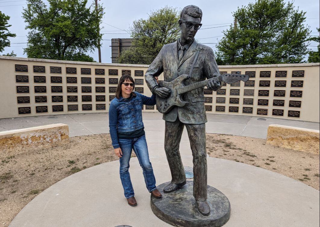 You’ve likely heard of the Hollywood Walk of Fame, known for engraved stars in the sidewalk to commemorate popular celebrities. But did you know Lubbock also has a Walk of Fame? Rather than stars in the sidewalk, however, this one features plaques on a wall to honor musicians from the area. The major draw to the West Texas Walk of Fame is a statue of Buddy Holly, Lubbock’s rock ‘n’ roll pioneer who opened for Elvis Presley and caught the world by storm before his untimely death at age 22. His legacy lives on in the city with the Buddy Holly Center, Buddy Holly House, Buddy Holly Gravesite, and more. Prairie Dog Town 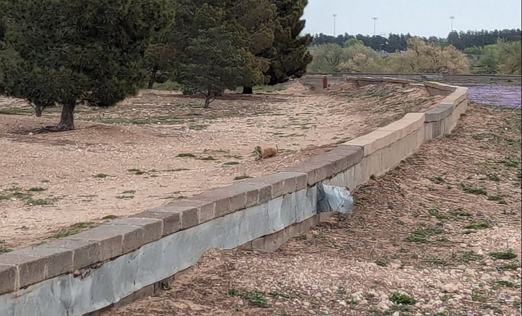 Prairie dogs are fun creatures to watch, with their extreme stillness while on lookout and their twitchiness when off guard duty. When we learned Lubbock featured a Prairie Dog Town, we had to check it out.
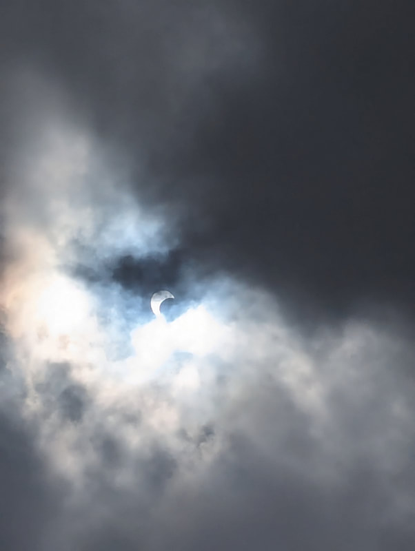
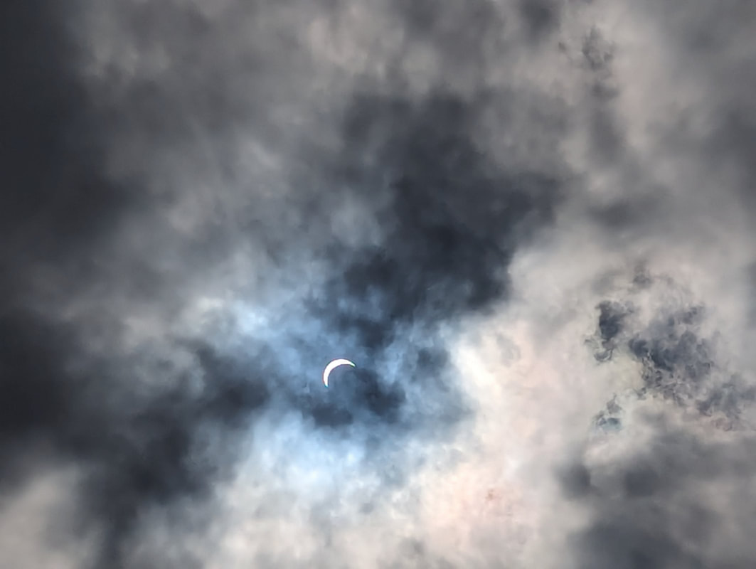
The dedicated space for the squirrel relatives got its start in 1935 when a man named K.N. Clapp wanted to do something to preserve the black-tailed prairie dog from extinction by the government’s poisoning program. The animal town began with four rodents and two burrows, with Clapp named the mayor of Prairie Dog Town in perpetuity. Over the years, the creatures multiplied, as did their burrows. We spent about an hour at the attraction, although we almost left pretty rapidly after not seeing any obvious signs of life. While observing the broad field from the cab of the truck, however, Bob noticed movement out in the distance. I left the truck to drop some trash in a wastecan and saw a prairie dog standing at attention outside the fence of the official enclosure. As I stood and watched, birds encroached on the creature, which held its ground, undeterred. The birds moved on, and the prairie dog went off duty, moving to another burrow. But it was fun to watch while the show lasted. These are just a few hidden gems we happened upon while visiting West Texas. Another trip another time will undoubtedly reveal more. Meanwhile, we adventure on, in anticipation of what lies ahead. You might also like Exploring Valley of Fire State Park in Nevada. 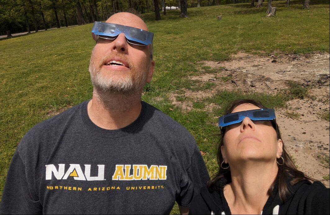 We had plotted to head east for our 2024 travels, unaware of the upcoming solar eclipse. When we discovered we’d be in Texas at the scheduled time of this rare phenomenon, we made plans to spend the week on its route. When the moon passes between Earth and the sun, it forms an eclipse, with the path of totality varying greatly. Seven years ago, in 2017, Americans had the opportunity to witness this event, with prime visibility stretching from Salem, Oregon, to Charleston, South Carolina. That was the first time for such an occurrence in the U.S. since 1979, when only five states were privy to totality. The 2024 solar eclipse extended viewing opportunities to numerous Americans, from Texas to Maine, for a chance to witness a total eclipse of the sun. Watching and Waiting The weather forecast in our location near Paris, Texas, called for clouds the day of the eclipse, so we weren’t sure what to expect. Would we be able to see the sensation? We gathered with a handful of fellow campers on a grassy knoll under a largely cloud-covered sky, solar glasses in hand, for our chance to view this wonder. As the clouds slowly moved, we caught glimpses of the disappearing sun through breaks in their cover — no glasses needed. The moon’s passing in front of the sun converted the orb to an arc. An occasional clear patch of sky emerged, allowing the brightness of the small sliver to penetrate through, forcing us to don our eyewear, which blocked everything but the yellow arc. As the moon obstructed more and more of the sun, sand bass in a nearby lake jumped as if it was evening, their activity increasing in the rare low light of midday. Birds hushed. The temperature dropped, making me grateful I had brought my sweatshirt. Light dissipated, and everything turned gray. 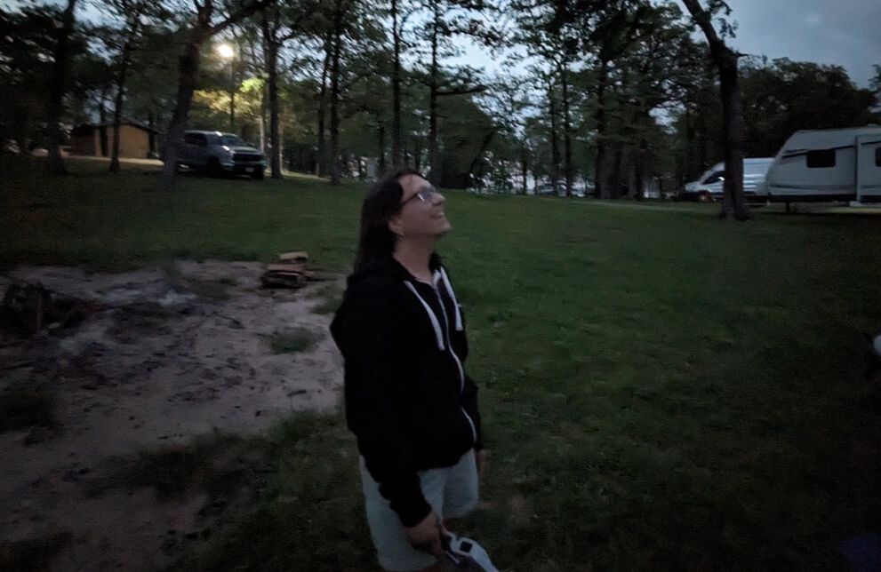 Viewing Totality Then our surroundings grew darker. The clouds vanished to showcase this anomaly of the moon completely blocking the sun from sight. A “ring of fire,” visible by the naked human eye, replaced the sun’s bright beam, its rays peeking out from behind the smaller moon. 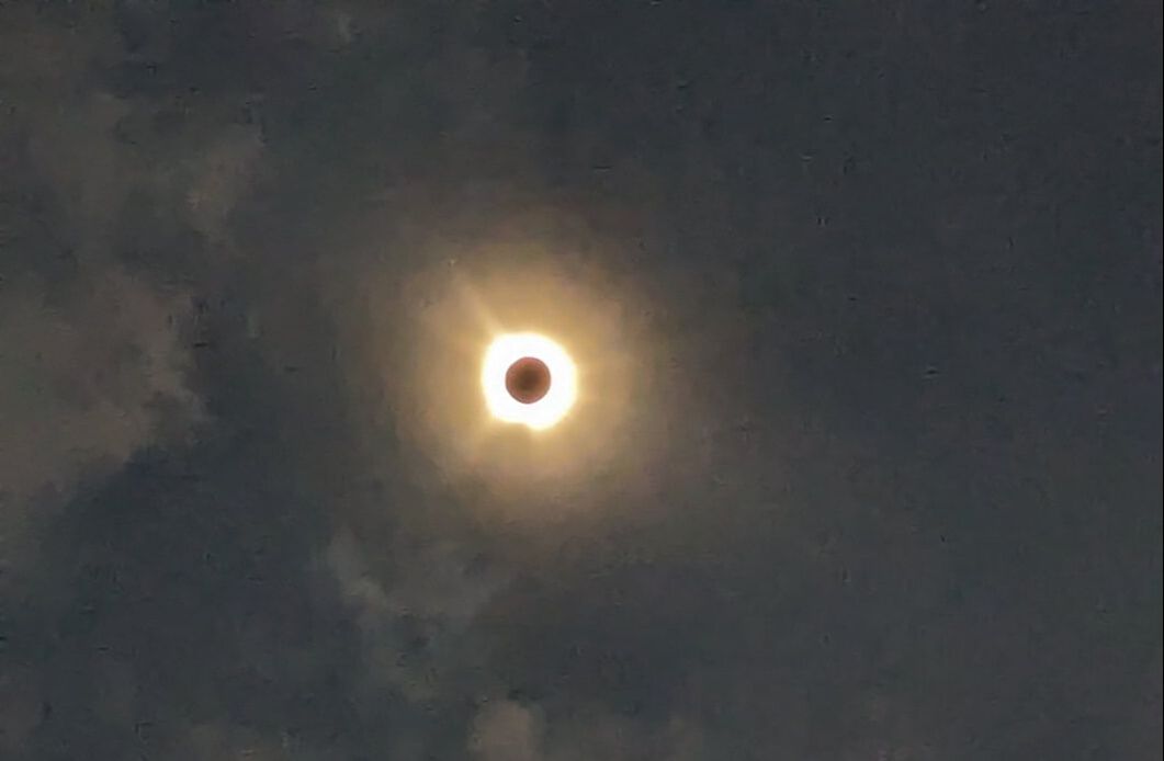 About four minutes later, a small red light materialized on one side of the halo, a sun ray poking through with the appearance of a diamond ring. Shortly thereafter, we had to put on our special glasses again if we wanted to continue looking at the growing crescent on the opposite side of where we had seen it before. 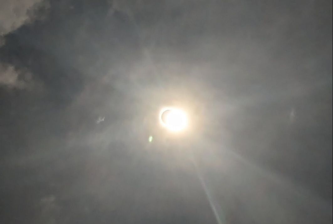 Darkness evaporated, birds started singing, fish stilled, and the temperature warmed. The moon continued moving away from the sun, and life as we know it returned to normal.
I remember seeing a partial eclipse in Arizona in 2017 by watching the sun’s shadow through a pinhole in a shoebox. Although cool, that paled in comparison to witnessing a total eclipse. We’re thankful we had the opportunity to observe this unique display and to do so in the company of fellow RVers. Life is good, and we are blessed. You might also like Experiencing the Wonder of the Northern Lights. 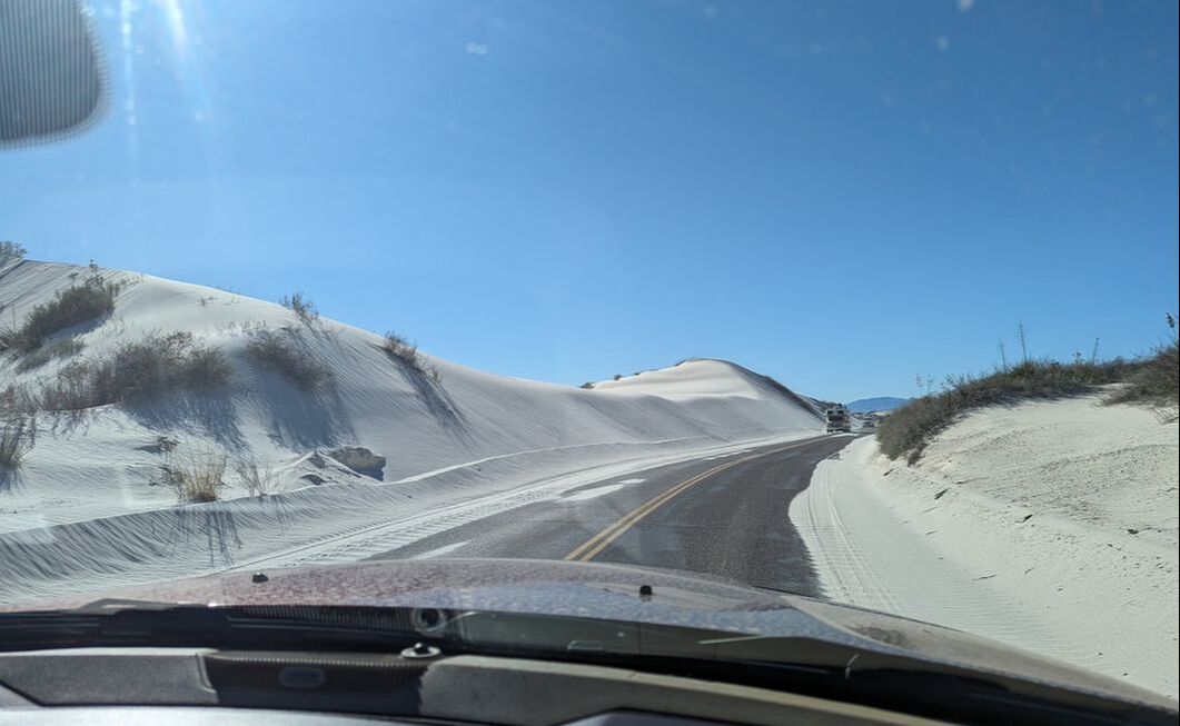 Alamogordo, New Mexico, may not sound like a destination. What drew us to the obscurely named city (meaning “fat cottonwood”) of just over 31,000 was its reputation for white sands: White Sands National Park and White Sands Missile Range. The city’s military history dates back to WWII and includes the gathering of more than 1,600 German scientists, technicians, and engineers after the war to advance rocketry, medicine, synthetic fuels, and other research. Today, missile testing still closes U.S. Highway 70. Although we didn’t see a missile launch from White Sands, we did see a Starlink rocket ascend while camped in the desert west of Phoenix. 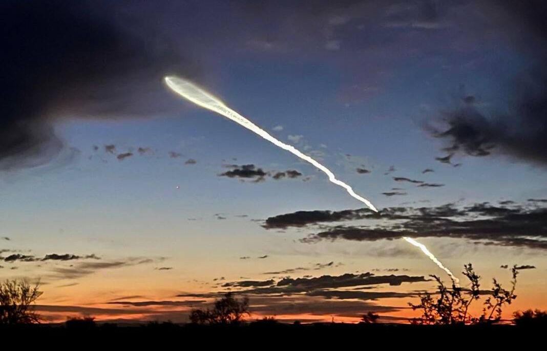 After spending a week living off-grid in Alamogordo, we found ourselves amazed at the abundant things the vicinity offers: the Southwest’s oldest zoo, myriad chain restaurants and hotels, unique experiences, and expansive mountain views. Our schedule didn’t allow for us to explore the White Sands Missile Range Museum, but we did find three adventurous things to do in Alamogordo: 1. Sand Sledding  By far my favorite thing we did in the area was sledding down sand dunes at White Sands National Park. The white sand, visible from space, is made from gypsum, which is the key ingredient in sheetrock and plaster. You can purchase a round sled and a block of wax at the visitor center gift shop and head out on the 8-mile Dunes Drive, stopping wherever you like to ascend a dune and sled down it — without getting cold. If a sled trail hasn’t been made, the first run can be a bit slow. We found the best success by waxing the bottom of the sled after every run or two to make the descent a thrill. The National Park Service app says there are three sledding areas of varying levels: beginner, intermediate, and experienced. We climbed an intermediate dune for our first run, amazed at the firmness of the sand under our feet, perhaps a result of the rain the day before. Although the hill looked awfully steep, one run down made it clear we needed that pitch to get enough speed for a smooth slide. After a few times of trudging up the dune and sledding down, we loaded back into Gulliver and drove to the steeper, experienced-level dunes, finding them exhilarating. We left with smiles plastered to our faces and somehow managed to avoid getting sand inside our shoes. 2. Exhibit Exploring 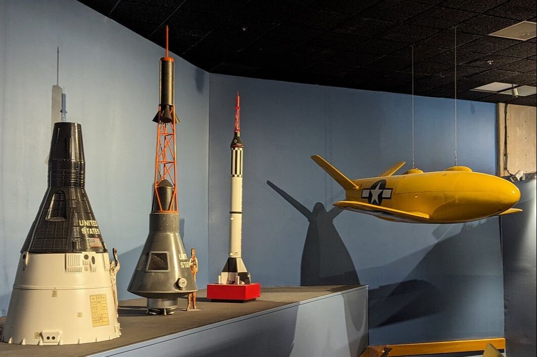 Alamogordo offers numerous museums to honor its railway and military history. The New Mexico Museum of Space History is well worth the $8 admission. It chronicles the progression of space and missile science in New Mexico, plus a whole lot more. A tour through the five-level facility starts on the fifth floor, leading visitors down through varying exhibits. One level is devoted to space science in New Mexico, including a commemoration to John P. Stapp, “the fastest man on Earth.” He sustained 46.2 Gs when testing the effects of gravity during deceleration while stationed at Holloman Air Force Base in Alamogordo. Another museum floor is dedicated to living and working in space. One is focused on rockets and missiles. We found the level about science fiction fascinating. Its placards discussed how many of the ideas in science fiction have become reality. The last level is an interactive one. But hands-on exhibits and photo ops are available throughout, including a flight simulator to land a space shuttle and a mock “Beam me up, Scotty” transporter, as seen on “Star Trek.”  After about four hours, we found ourselves in the museum’s gift shop. If the weather had been cooperative, we would have stayed longer to explore the outdoor exhibits. 3. Nut Noshing 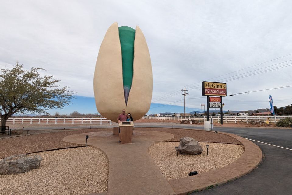 No visit to Alamogordo would be complete without a trip to PistachioLand, home of the world’s largest pistachio. Besides photo ops, the unique attraction features pistachio and wine tasting, nutty gifts, fudge and ice cream made on the premises, and farm tours for only $3 per person (at the time of this writing).
The 30-foot towering pistachio at the entrance to the locale was erected in 2007 to honor the late Tom McGinn, who owned and ran the ranch and first introduced pistachio farming to southern New Mexico. On the tour through a portion of the farm’s 125 acres, we learned how pistachio trees had to be grafted into native trunks from the Middle East in order to survive against southwestern America’s harsh environmental conditions. Most U.S.-grown pistachios (97%) come from California. The other 3% come from Arizona and New Mexico. PistachioLand offers a variety of flavored nuts, all salted and roasted on the ranch, from lemon lime to cinnamon to garlic to green chile. There’s something for everyone. We left with a bag of red chile-flavored pistachios and a cone of pistachio ice cream, thankful for the experience that reminded us of the Corn Palace in Mitchell, South Dakota. You might also like 3 Cool Things to Do in Yuma, Arizona. 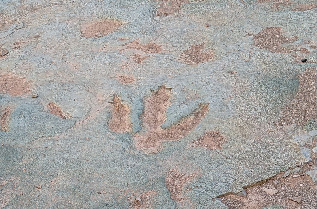 The red rocks of Moab, Utah, draw upward of 1.8 million visitors annually to take in their beauty. We had passed through once, in awe of the vibrant scenery around us — and of the number of people thronging the road. Despite the crowds, the city of 5,200 left us with a desire to return when we had more time to explore. The big attraction in Moab is Arches National Park, which beckons tourists to navigate its 76,519 acres in search of more than 2,000 sandstone arches. A drive through the park provides glimpses of a handful of the natural structures. Seeing the others requires hikes of varying lengths. 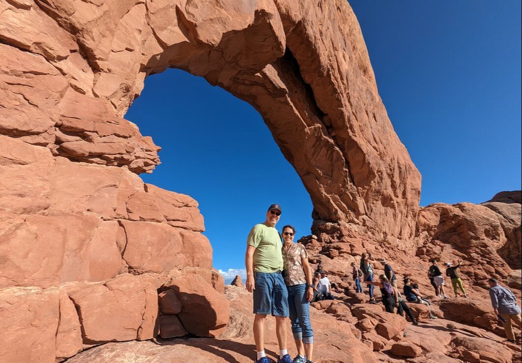 In a 3.5-hour span with multiple stops, we lay eyes on about a dozen of the magnificent rock formations, in addition to petrified sand dunes and other captivating displays. The mesmerizing beauty left us in awe and hearkened back to a bygone era, documented at one point by petroglyphs on a rock. One thing we noticed missing from this national park that we’d encountered at others was wildlife — although Gulliver did get a not-so-secret admirer. 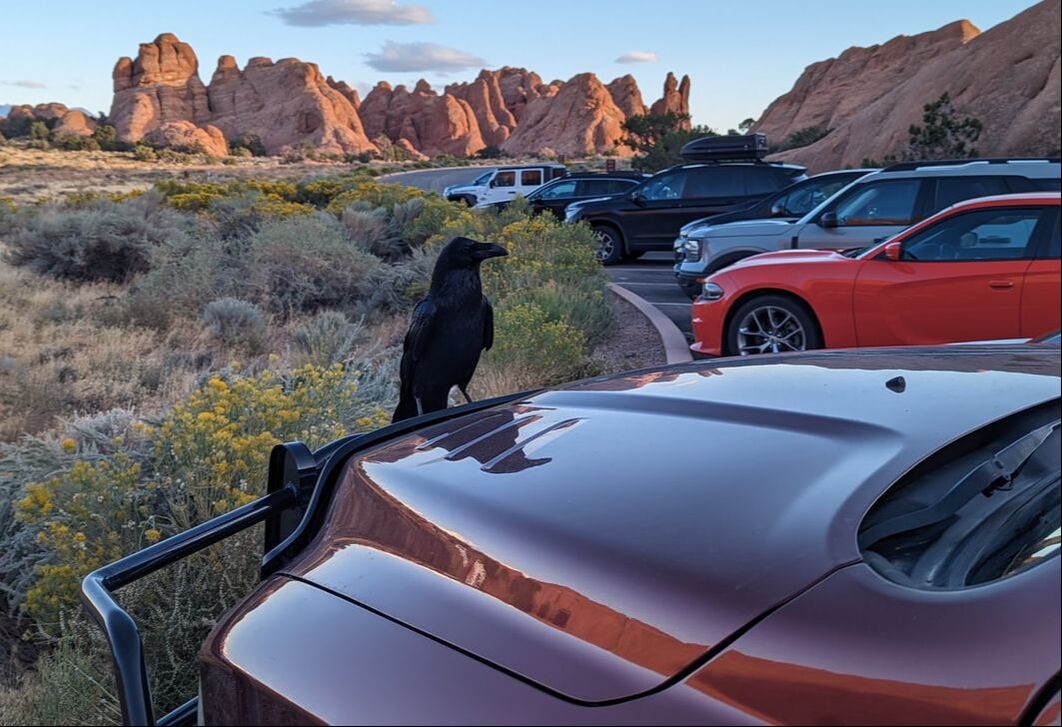 Going on a Dino Hunt A lesser-known noteworthy aspect of Moab is its dinosaur history. In addition to a couple of museums, the city offers three dinosaur track sites, with imprints of massive wildlife of old. Mill Canyon Dinosaur Tracksite showcases fossilized dinosaur footprints preserved in limestone, protected by a boardwalk around the “stomping ground.” 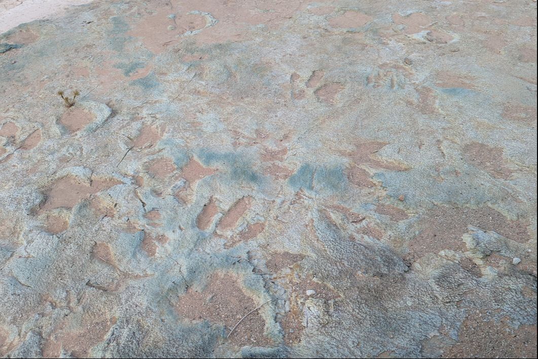 According to plaques at the site, algae covered the shallow lake, capturing the dinosaurs’ tracks before the water, mud, and algae dried up and hardened into limestone, with the prints intact. We saw 10 different kinds of tracks, representing dinos of varying sizes, from velociraptor up to brontosaurus. Thinking about the gargantuan creatures roaming the area made us feel small and gave us a completely different perspective on our surroundings. Wild Pterodactyl Chase Wanting to see a more impressive display, we headed to Copper Ridge Dinosaur Trackways and set out on Dino Flow Trail, which we believed to be 1.5 miles. Nearly 3 miles later, it had become quite evident I had taken Bob on a wild pterodactyl chase. After the trail meandered over multiple rises and around numerous bends, no track site came into view. We decided to cut our losses and turn around. Returning to the parking area, the actual location of the imprints became apparent. We had read that this location offered two areas of tracks. We didn't realize they both started at the same trail. Reviews said the site closest to the beginning of the Copper Mine Ridge trailhead wasn’t too impressive. The more alluring site lay 1.5 miles up the trail. Having already put 5 miles under our belts, we forwent the latter and settled for the first, finding it plenty awe-inspiring. We could actually stand in some of the enormous footprints and imagine the weight and size of the behemoths that made them. 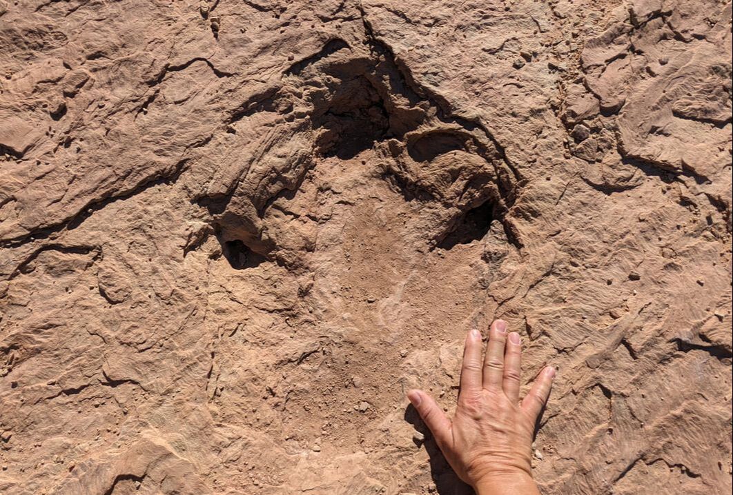 Picking a Bone Our dino hunt didn’t end there. The Moab area also offers a place to see fossilized dinosaur bones intact in hardened rocks, not in a museum. We headed to the Mill Canyon Dinosaur Bone Trail. A sign warning of soft sand and recommending only four-wheel-drive vehicles beyond that point stopped us in our tracks. Since Gulliver isn’t four-wheel-drive, we didn’t want to risk getting stuck in the soft sand like we had done in Traverse City, Michigan. It seemed we’d have to end our dino hunt. I reread reviews about the dinosaur bone trail and learned we weren’t the only ones who didn’t want to drive beyond the sign. Others had parked nearby and walked the half mile to the trailhead. We decided the additional 1-mile round-trip trek would be worth it. The walk through soft sand and over rocks confirmed we had made the right decision in not taking Gulliver down the path. Arriving at the Mill Canyon Dinosaur Bone Trail, we noticed paths in three different directions. Where were we to find the bones? We opted for the trail just past a visitor sign-in podium and encountered a plaque a few strides later. We had chosen wisely. 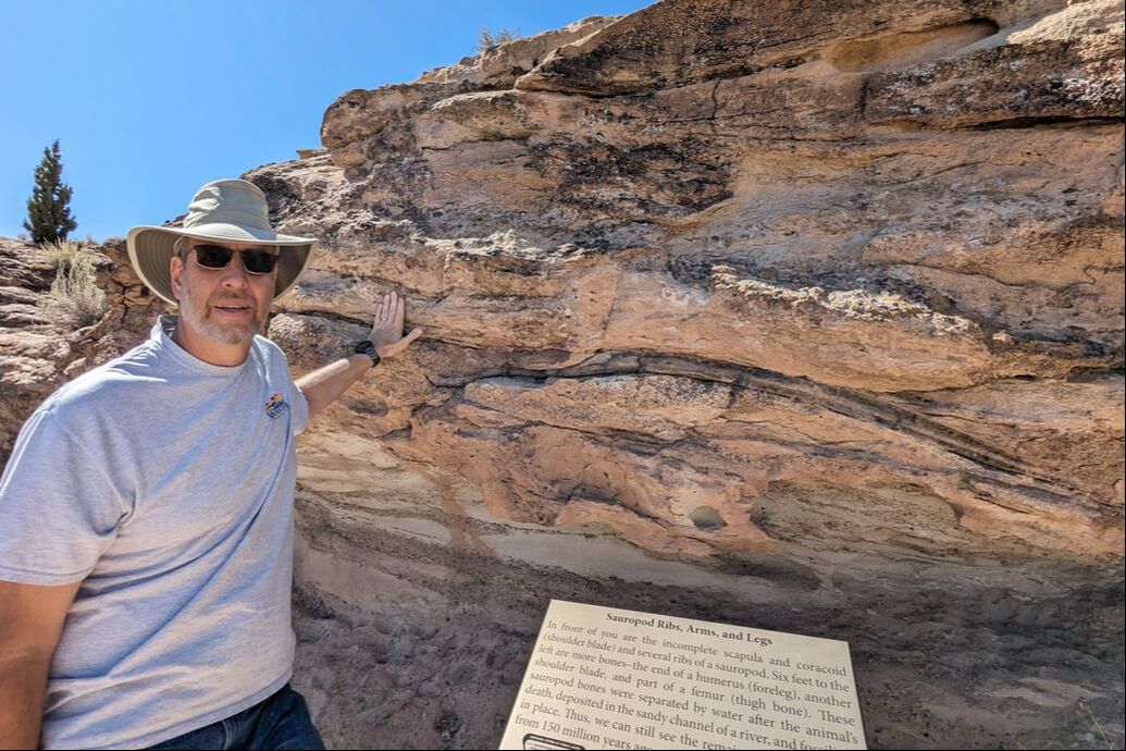 Hardened Evidence Signs like the first were sprinkled along the trail, describing what to find in each area, with detailed information about where to look. Had it not been for the plaques, we wouldn’t have known the rock color variances we observed as we walked along a ridge were actually bones from giants that once walked the land. The fossils looked darker than the rocks in which they were wedged. More amazingly, they felt different from the rock surrounding them, lighter in weight like calcified bones. 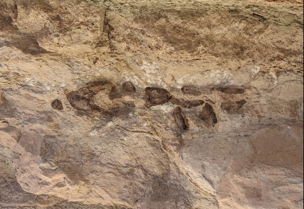 We saw and touched foot, toe, arm, leg, rib, and spine skeletal parts from sauropods — the generic name for plant-eating dinosaurs with long necks and tails that could span 20 to 112 feet in length. I found it hard to believe that a creature so large could survive on plants alone. We also observed bones from a meat-eating allosaurus with a max length of about 30 feet.
Playing paleontologist made our Jurassic adventure a fun and memorable experience. It also gave us a greater appreciation for prehistoric times, when colossal animals roamed the vast Earth. You might also like Exploring Valley of Fire State Park in Nevada.  The state of Montana stretches across 147,000 square miles, encompassing Glacier National Park and numerous national forests. Its wide-open spaces offer panoramic views of the big sky, giving it the nickname “Big Sky Country” and making it a welcome sight after a summer in expansive Alaska. We had spent time in the 41st state on tour with the Commemorative Air Force, but we hadn’t visited with our fifth wheel. Wanting to put Montana on our RV map, we made a point to stop there for a week in Missoula, in the western part of the state. The scenic drive down from Canada took us around the enormous Flathead Lake and past wild bison, deer, and turkeys. Missoula features Fort Missoula, which dates back to 1877; Hiawatha Trail, a 15-mile downhill bike trail through nine train tunnels and across seven trestles (closed when we were there); breweries; museums; and a whole lot more. It’s famous for trout fishing, as well as a few other things you might not be aware of: 1. Smokejumping 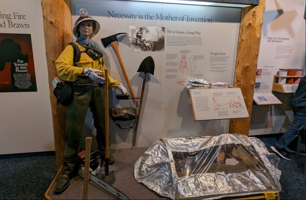 Missoula has a long history with firefighting and smokejumping, dating back to 1919, when the city started engaging in patrolling fires from the air over national forests in the western states. Since that time, the practice has progressed to include dropping teams of “smokejumpers” into areas near fires to fight them. We went to the Smokejumper Visitor Center for a tour to learn more about this fascinating aspect of Montana history and were not disappointed. Displays provided information and visuals about the equipment needed to parachute into a fire area to put it out. Jumpers, who sometimes land in trees instead of open spaces, have to carry more than 100 pounds of supplies with them for the first 24 hours. Modern parachutes provide more firefighter control than early models did, giving jumpers better chances of landing in open areas. Additional supplies, including firefighting tools and rations for 48 hours, are dropped in after firefighters reach their targets. The tour included walking through the working smokejumper facility and seeing where parachutes are packed, where firefighters sew their own gear, where parachutes are tested, and more. Part of the U.S. National Forest Service, the Smokejumper Visitor Center tour is free and well worth it if you find yourself in Missoula and have an hour to kill. 2. Mountain Flying 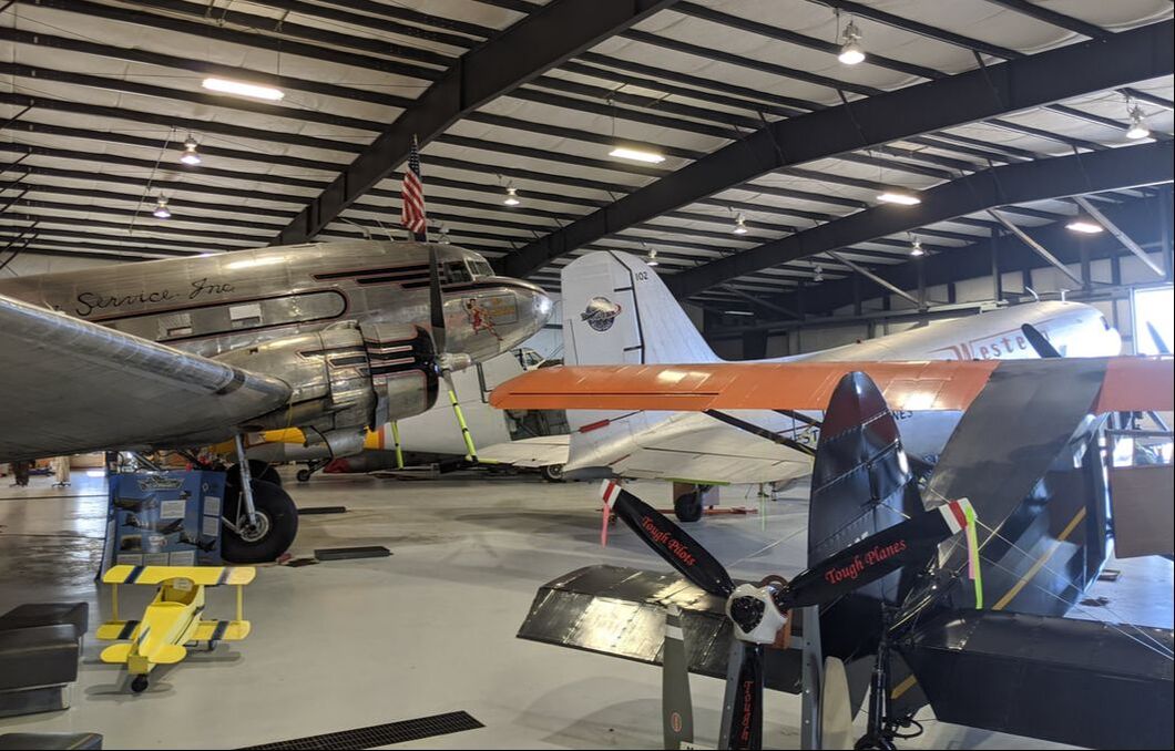 Although Idaho holds the title for the first smoke jump, Montana is the birthplace of mountain flying. Missoula’s Museum of Mountain Flying pays homage to that heritage. Featuring aircraft, vehicles, displays, photos, and artifacts, the hangar honors and preserves the history of the Johnson Flying Service from the 1920s to the 1970s for a reasonable price: $4 for adults and $10 for a family. The centerpiece of the museum is a 75-year-old restored and airworthy C-47 dubbed “Miss Montana.” Although the airplane never saw combat during WWII, it holds a special place in the hearts of many Montanas for its rich history in smokejumping — including the Mann Gulch Fire of 1949 — and transporting cargo and civilians. The plane also took part in the 75th anniversary of Normandy. You can even watch a film about the restoration process to make that happen. 3. Bison Roaming 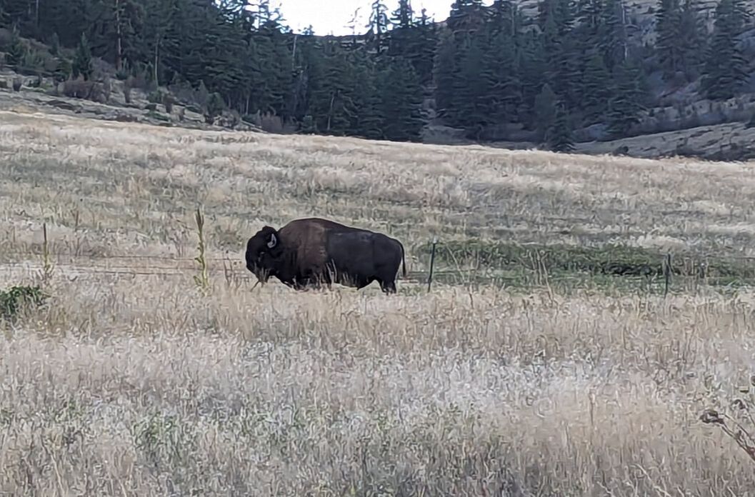 Another interesting thing to see in the Missoula area is the Bison Range. Montana’s wide-open spaces allow plenty of room for bison to roam. We made an hourlong trek outside the city to the range to check it out. A $20 per-vehicle fee gives visitors the option to drive the two-hour combined Mountain Drive and Prairie Drive or the out-and-back Prairie Drive alone. Unfortunately, we arrived too late to tour the higher Mountain Drive, where we can only guess more animals wandered closer to the road than they did on the Prairie Drive. Although we saw some bison and deer, the experience paled in comparison to how close we were able to get to wildlife on the Alaska Highway. Having grown up hearing about buffalo, we couldn’t help but wonder about the difference between bison and buffalo. You may be wondering too. Suffice it to say that any animal you come across in the U.S. that you think is a buffalo is actually a bison. Buffalo are native to Asia and Africa. Bison, characterized by a big hump on their backs, graze in North America and Europe. They’re also larger than buffalo. (Think water buffalo for comparison.) 4. Carousel Designing 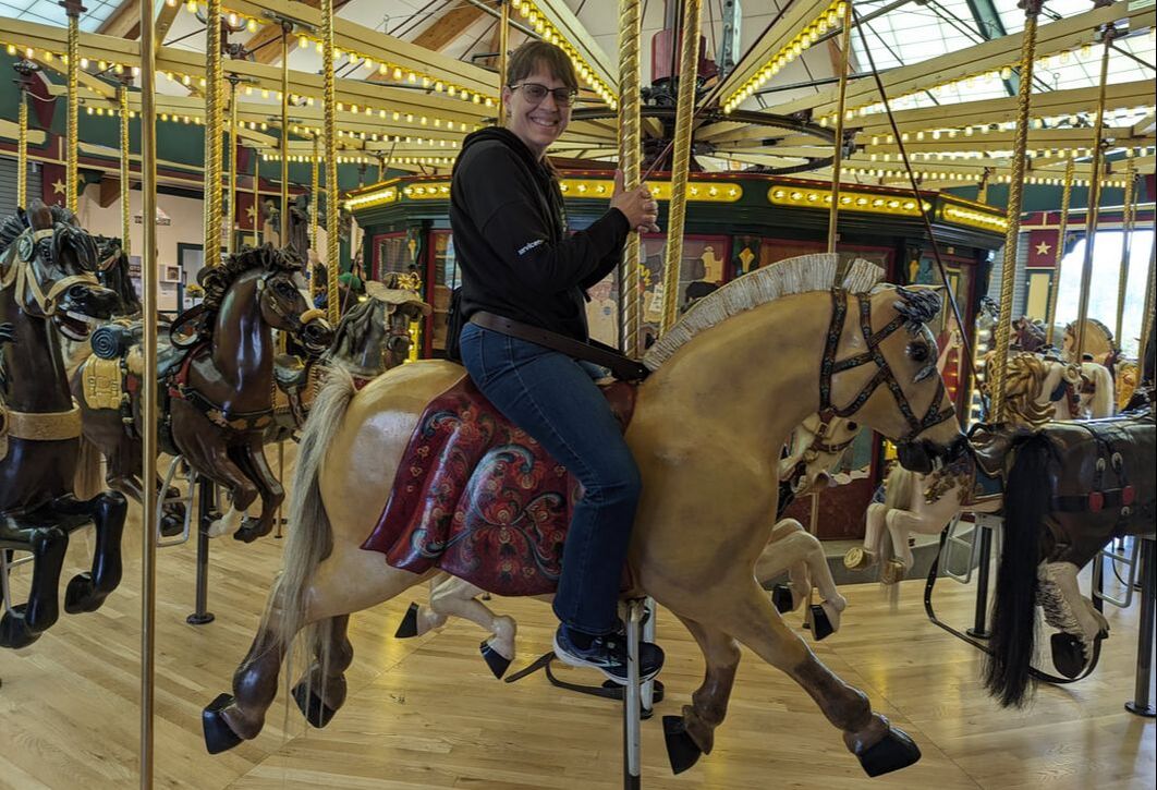 Carousels are common attractions around the world. What makes A Carousel for Missoula special is the story behind it — and its speed. It’s by far the fastest carousel I’ve ever ridden on. There’s a good reason they make you buckle in on your animal of choice.
Initiated by a Missoula cabinet maker, A Carousel for Missoula is a testament to volunteerism at its finest. Over a four-year period, the cabinet maker and several wood carvers, mechanics, painters, and artists donated more than 100,000 hours to create a masterpiece. The community got involved too. Schoolchildren collected more than 1 million pennies to pay for four ponies. Housed in a building downtown near Clark Fork River to protect it from the elements, the carousel delights children of all ages. Rides are $1 for children and $2 for ages 12 and up. You might also like Investigating Idaho, the Country’s 43rd State. 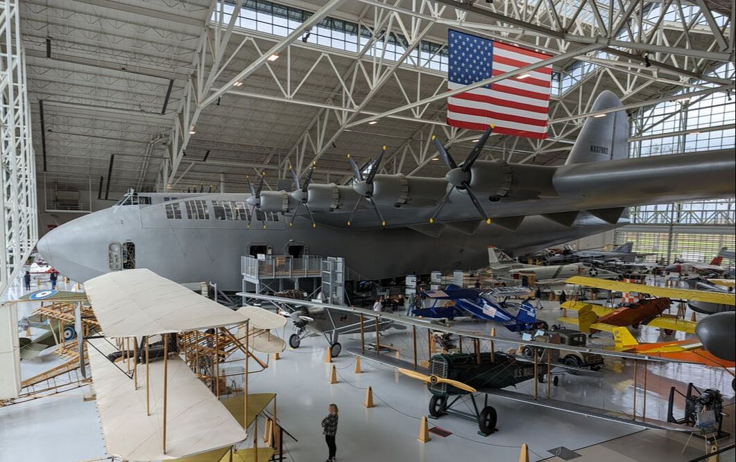 Ever heard of McMinnville, Oregon? We hadn’t either until a fellow RVer we met in Maine last summer dropped the name. The city of approximately 34,000 people became known for its vineyards and wineries. Although those still draw regulars and visitors alike, McMinnville gained a bigger claim to fame in 1993 when it received shipment of the Spruce Goose. I had heard my dad mention the Spruce Goose many times while growing up. Having taken a number of cruises out of Long Beach, California, I knew the Spruce Goose no longer resided there, as its former public hangar dome is now Carnival’s cruise terminal. But I didn’t know where the plane had moved to and had never laid eyes on it. When we learned it was only 1.5 hours from our campground in Eugene, Oregon, we had to go see it for ourselves. What is the Spruce Goose? The Spruce Goose is the world’s largest wooden airplane. The brainchild of shipbuilder Henry Kaiser, the “flying boat,” as it’s sometimes called, was created to transport troops and cargo to the Atlantic Ocean during WWII. Businessman, engineer, film producer, and pilot Howard Hughes, one of the richest people in the world in his lifetime, designed and built the eight-engine behemoth. Its wings span nearly 321 feet. It weighs 300,000 pounds empty. And it stands more than 79 feet tall.  Because of war efforts, Hughes was unable to secure any metal for the project, so he resorted to wood, using the design of a wooden boat as his guide. Contrary to popular belief, the bulk of the plane consists of birch, not spruce. Only the engines, electronics, and screws are not made of wood. Five years after the building project got underway, Hughes sat in the cockpit behind the yoke to test the flying boat on the water of Long Beach Harbor. After two runs of getting the plane up to speed, Hughes wanted to prove that his mammoth creation could indeed fly. On the third test run, he lifted the plane and kept it in the air for about one mile before landing on the water. Moving a Colossus Because the war had ended, the plane never saw flight again. It sat in a hangar for 33 years. After Hughes died in 1976, the Wrather Corp. moved the aircraft into a domed hangar near the Queen Mary in Long Beach, where both could be seen by spectators. Disney acquired the Wrather Corp. but, after finding the attractions not profitable, decided to cut ties with them. Bids started pouring in from locations wanting to create a permanent home for the Spruce Goose. The proposal by Evergreen Aviation & Space Museum in McMinnville won, and plans were drafted to transport the flying boat from Southern California to Midwestern Oregon. The massive plane was disassembled and transported in pieces by barges up the West Coast to Northern Oregon. From there, the barges floated the Columbia and Willamette rivers to Portland, Oregon, where the aircraft parts were stored until water levels allowed the structures to float the Willamette River without crashing into any bridges. Several months later, the pieces arrived in McMinnville, delivered by truck the last 7.5 miles. A Visit to Evergreen Museum After nearly eight years of restoration to put all the pieces back together, Evergreen Aviation & Space Museum opened to delight young and old with close-up views of Howard Hughes’ flying boat. Seeing the mammoth marvel dwarfs all other planes in comparison. To think it was actually able to lift off is astounding. We enjoyed touring the expansive museum and learning more about the plane and its history, but especially seeing it up close. We even walked into a portion of the cargo area, where Plexiglass allowed us to look to the bow and aft of the plane. For an additional $30, up to four people can take a 15-minute tour of the cockpit. We opted to forgo that. Although the Spruce Goose is the main attraction at Evergreen Museum, the gallery houses numerous other aircraft, from a replica of the Wright Flyer to planes from the Golden Age to warbirds and more.  Our $22 admission also granted us access to the Space Museum in another building. It takes visitors on a journey from the beginning of the space age through the Apollo missions and even includes a to-scale lunar module. We found the secondary hangar mesmerizing. It also included a sleek SR-71 Blackbird plane and an A-10 Warthog. 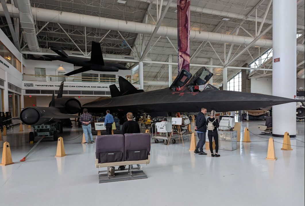 If you’re ever near Salem, Oregon, a trip to the Evergreen Aviation & Space Museum is well worth the visit. We learned new things and found the innovations there inspiring.
You might also like 4 Highlights of Touring with a WWII Bomber.  Although Idaho is famous for potatoes, it’s not dubbed “The Potato State.” No, it’s called “The Gem State” and is one of only two places in the world where you can find star garnet. (The other is India.) We didn’t see any gems, but we did see some other things the state has a reputation for. Picturesque Scenery Surrounded by towering mountains, Idaho offers a lot of beauty. During our visit, snow capped the peaks, making them that much more attractive — and a boon to skiers. In summertime, people venture to the mountains for hiking, camping, and other outdoor adventures. Idaho even claims its own glacier, Borah Glacier. It’s part of Mount Borah, the highest peak in the state, soaring 12,668 feet above sea level, according to Sawtooth Mountain Guides. The state is also known for its numerous waterfalls, some of which are backed by city names: Twin Falls, Idaho Falls, Post Falls, and American Falls. Although we visited Twin Falls, inclement weather kept us from venturing to Shoshone Falls to see if they were flowing. Together, Idaho and Oregon boast North America’s deepest gorge: Hells Canyon, measuring 7,913 feet deep, according to the U.S. Forest Service. We didn’t see that, but we did see the Snake River, which is responsible for Hells Canyon. Aptly named, the Snake River snakes its way from Wyoming, across southern Idaho, and into Washington state before flowing into the Pacific Ocean. 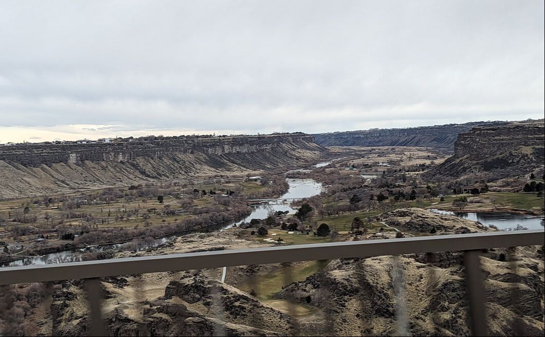 Thrilling Rodeos Another thing Idaho is known for is rodeos. The 1900s kicked off the state’s most famous bucking horse competition, the Snake River Stampede. Today, that and the Caldwell Night Rodeo draw fans of all ages. Although we didn’t witness either of those famous exhibitions, we did take in our first bucking competition as part of the Professional Bull Riders, or PBR, circuit in Nampa. Guys from age 18 to 36 took turns riding bucking bulls to see who could stay on for 8 seconds. A number of them made it. The majority did not.  Those who got bucked off ran from the unhappy beasts to keep from getting hurt, while a trio of U.S. Border Patrol agents distracted the animals to get them away from the riders and through an exit chute. A guy dressed as a clown entertained the crowd between buck-riding attempts. The show proved entertaining, and we’re glad we got to take part. We look forward to when we can enjoy a rodeo with multiple events. Historical Airplanes You may not realize it, but Idaho also hosts an annual Warbird Roundup in August, sponsored by the Warhawk Air Museum. We saw signs for the museum and knew it wasn’t far from where we stayed, so we took advantage of an opportunity to explore it. The museum has about 15 warbirds on display, including a P-51 Mustang, a couple of MIGs, a T-6 Texan, a biplane, and two P-40s that have movie history. The planes were impressive, as was the wealth of history encased throughout the two-hangar gallery. 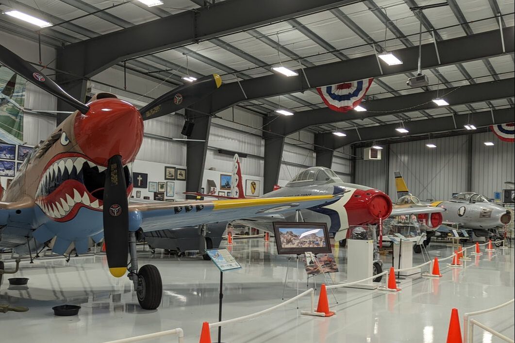 We walked among case after case of paraphernalia from Idaho veterans, examined an in-depth Women Airforce Service Pilots (WASP) exhibit, and learned things we didn’t know about Hitler and the Jews in WWII.
Before we left, a photo of a familiar B-17, “Sentimental Journey,” from the Commemorative Air Force Airbase Arizona Flying Museum caught our eye. Since we work on and around that plane, seeing it made us feel right at home. Idaho has much more to offer than scenery, rodeos, and warbirds. It’s also the lentils capital of the world and home to the most hot springs in the U.S., among other things. We’ll have to return when we can spend more time investigating the state’s uniqueness. You might also like Magnificent Rock Formations. 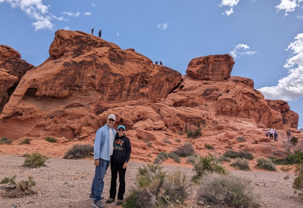 We were looking for a place to boondock near Las Vegas to start our ascent north. We found what looked to be a great spot: Valley of Fire West Dispersed Camping, a swath of Bureau of Land Management (BLM) land known to have unofficial campsites (areas to pull off a dirt road and set up camp). When we told the boondocking community we were with at the time about our plans, they informed us Valley of Fire was a beautiful state park worth investigating. If not for their report, we may have never discovered this hidden gem, and we would have missed a breathtaking excursion. Surrounded by Red Rocks Other than red rock formations, we didn’t know what to expect as we drove 5 miles from our dispersed campsite toward the western park entrance. As we rounded the last bend before the payment booth, red rocks came into view. 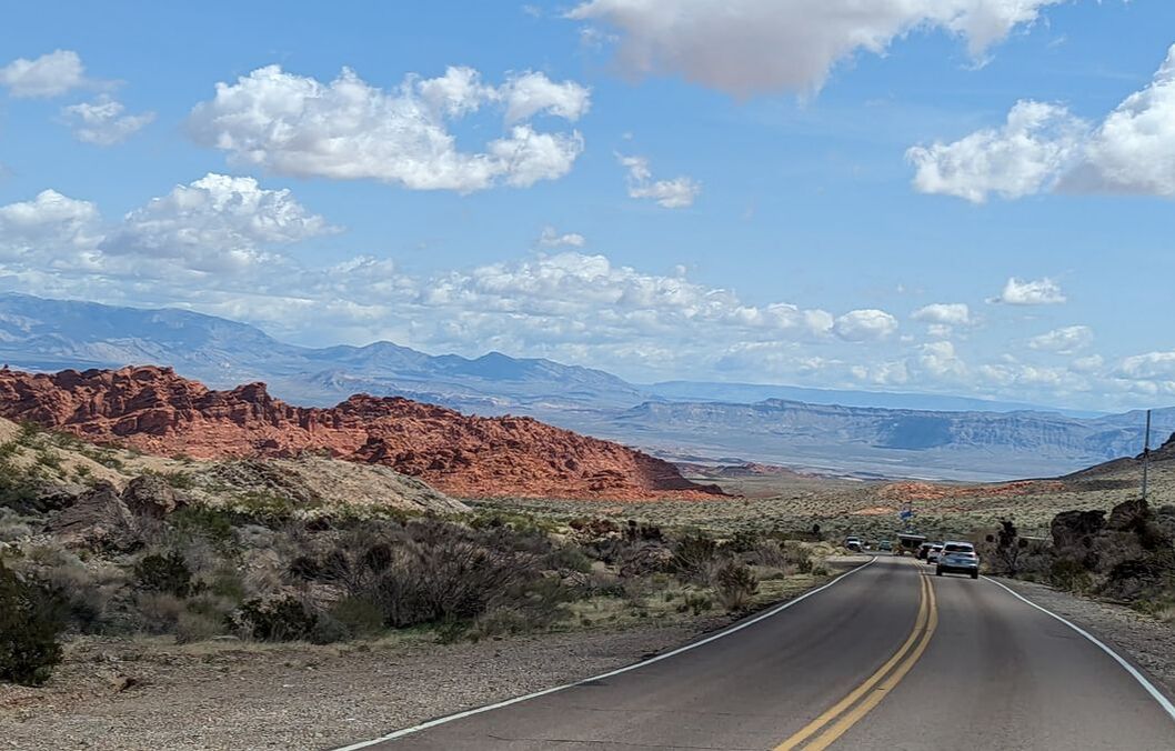 In exchange for a $15 nonresident fee, a park ranger handed us a receipt and a brochure. Off we went down the 7-mile Valley of Fire Road through the park, stopping at the first parking lot we came to: Beehives. Beehive-shaped rock formations mesmerized us. We climbed a little, snapped some photos, and found ourselves in awe. And this was only the beginning. 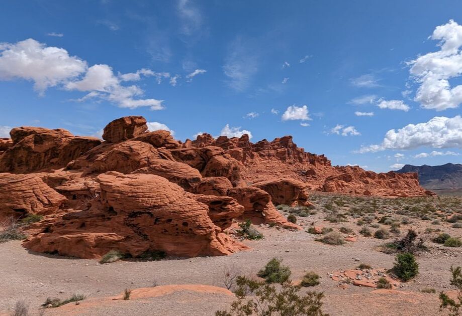 We continued on, the red rocks becoming more plentiful. We turned off the main road to check out the campgrounds and see what we were missing. We had considered staying in the park for up to a week once we learned about that option. The $35 nightly fee for out-of-staters was reasonable, but reviews we read talked about the challenges of getting a spot on a first-come, first-served basis. Surrounded by picturesque flaming beauty, the campgrounds are nice. One felt a little more cramped than the other due to the towering rock formations surrounding it. Seeing the established campsites made us appreciate the vastness of our boondocking spot and confirmed we had made the right decision. 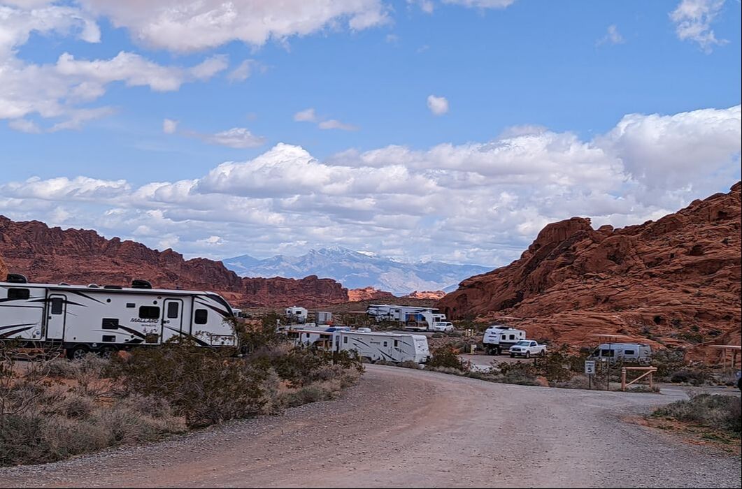 Colorful Panorama Back on the main road, we passed the Visitor Center and climbed out of a valley between red rocks on the aptly named Scenic Drive. We parked at a spot called Rainbow Vista and embarked on foot on a 1-mile, round-trip trail to a canyon overlook. Rainbow Vista is a fitting name for this area, as it offers panoramic views of vibrant color contrasts: reds, tans, greens, blues, and yellows against a clear blue sky dotted with puffy white clouds. As we traipsed through the red sand and over rocks, we couldn’t help but marvel at God’s beautiful creation all around us. 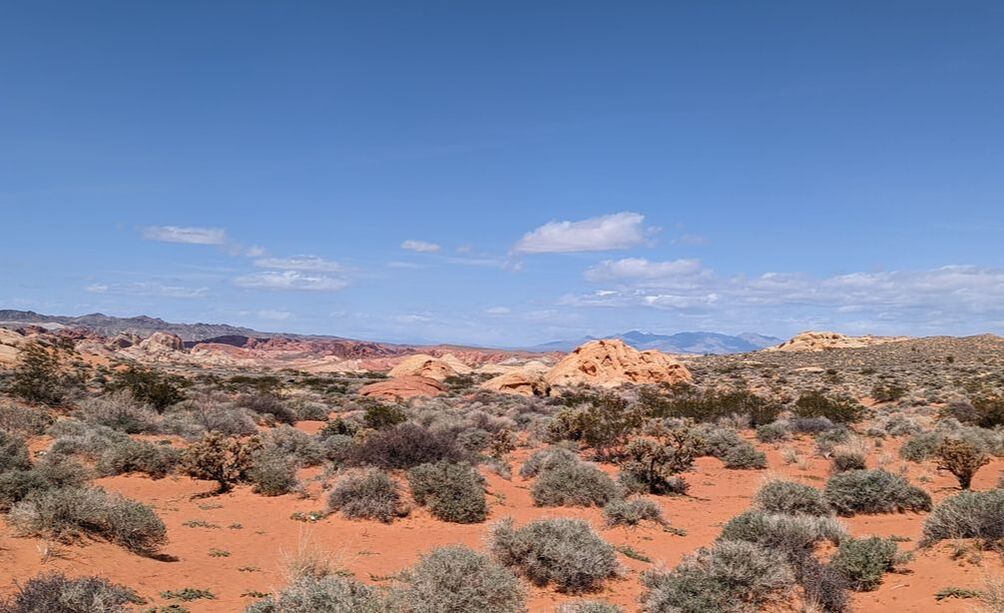 After rehydrating, we continued on Scenic Drive as the red rocks transitioned to white domes and pinks and pastels. We got out again for a short jaunt at the Pink/Pastel Canyon before heading back down to Valley of Fire Road and the Visitor Center. 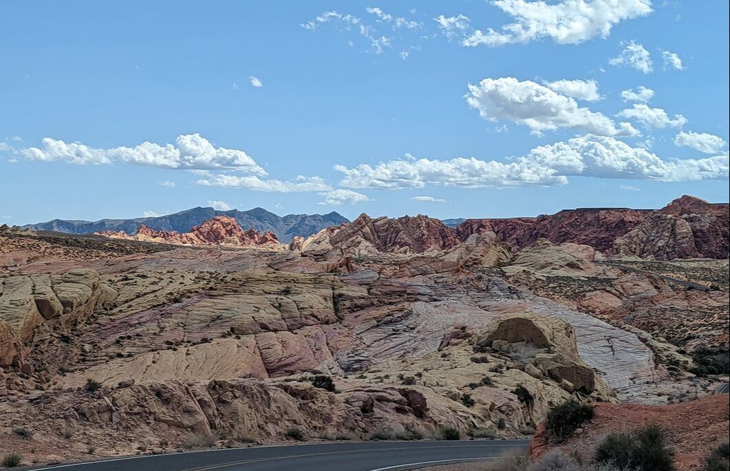 A History Lesson Inside the Visitor Center, we found a museum complete with descriptions of the different types of rocks in the area, the history of the peoples who had lived in the region, a collection of arrowheads and other artifacts and, of course, a gift shop. We learned the majority of the formations we saw were Aztec sandstone. The lighter colors were limestone. The concrete-looking rocks were conglomerate. We also discovered Valley of Fire was Nevada’s first state park. It opened in 1934, but the road through it dates back to 1912, when it was created to connect Salt Lake City and Los Angeles. My favorite part of the museum was learning about the people who had lived in the area and how they had survived and thrived. I even saw a remnant pair of handwoven sandals made from plants. Bob enjoyed learning about the variety of rocks. Treasure in the Wasteland Back in Gulliver, we decided to continue on Valley of Fire Road and exit on the east side, near Lake Mead. The scenic drive took us past seven natural pillars, a formation named Seven Sisters. It also led us to Elephant Rock. We parked there and hiked a little over a mile to see the structure bearing the name. 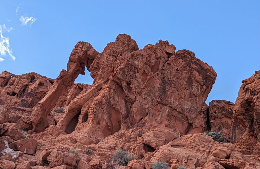 Once we exited the park, I kept looking to my left, amazed at the lack of red rocks. A few formations hinted at the beauty behind them, confirming that Valley of Fire is indeed a hidden gem. It truly is worth seeing up close and personal, as pictures don’t do it justice.
You might also like Magnificent Rock Formations. |
AuthorThis is the travel blog of full-time RVers Bob and Lana Gates and our truck, Gulliver, and fifth wheel, Tagalong. Categories
All
Archives
July 2024
|


 RSS Feed